Using Vertica requires an understanding of the Open Geospatial Consortium (OGC) concepts and capabilities. For more information, see the OGC Simple Feature Access Part 1 - Common Architecture specification.
This is the multi-page printable view of this section. Click here to print.
OGC spatial definitions
Using Vertica requires an understanding of the Open Geospatial Consortium (OGC) concepts and capabilities.
- 1: Spatial classes
- 1.1: Point
- 1.2: Multipoint
- 1.3: Linestring
- 1.4: Multilinestring
- 1.5: Polygon
- 1.6: Multipolygon
- 2: Spatial object representations
- 2.1: Well-known text (WKT)
- 2.2: Well-known binary (WKB)
- 3: Spatial definitions
- 3.1: Boundary
- 3.2: Buffer
- 3.3: Contains
- 3.4: Convex hull
- 3.5: Crosses
- 3.6: Disjoint
- 3.7: Envelope
- 3.8: Equals
- 3.9: Exterior
- 3.10: GeometryCollection
- 3.11: Interior
- 3.12: Intersection
- 3.13: Overlaps
- 3.14: Relates
- 3.15: Simple
- 3.16: Symmetric difference
- 3.17: Union
- 3.18: Validity
- 3.19: Within
1 - Spatial classes
Vertica supports several classes of objects, as defined in the OGC standards.
Vertica supports several classes of objects, as defined in the OGC standards.
1.1 - Point
A location in two-dimensional space that is identified by one of the following:.
A location in two-dimensional space that is identified by one of the following:
-
X and Y coordinates
-
Longitude and latitude values
A point has dimension 0 and no boundary.
Examples
The following example uses a GEOMETRY point:
=> CREATE TABLE point_geo (gid int, geom GEOMETRY(100));
CREATE TABLE
=> COPY point_geo(gid, gx filler LONG VARCHAR, geom AS ST_GeomFromText(gx)) FROM stdin delimiter ',';
Enter data to be copied followed by a newline.
End with a backslash and a period on a line by itself.
>>1, POINT(3 5)
>>\.
=> SELECT gid, ST_AsText(geom) FROM point_geo;
 gid |  ST_AsText
-----+-------------
   1 | POINT (3 5)
(1 row)
The following example uses a GEOGRAPHY point:
=> CREATE TABLE point_geog (gid int, geog geography(100));
CREATE TABLE
=> COPY point_geog(gid, gx filler LONG VARCHAR, geog AS ST_GeographyFromText(gx)) FROM stdin delimiter ',';
Enter data to be copied followed by a newline.
End with a backslash and a period on a line by itself.
>>1, POINT(42 71)
>>\.
=> SELECT gid, ST_AsText(geog) FROM point_geog;
 gid |   ST_AsText
-----+---------------
   1 | POINT (42 71)
(1 row)
1.2 - Multipoint
A set of one or more points.
A set of one or more points. A multipoint object has dimension 0 and no boundary.
Examples
The following example uses a GEOMETRY multipoint:
=> CREATE TABLE mpoint_geo (gid int, geom GEOMETRY(1000));
CREATE TABLE
=> COPY mpoint_geo(gid, gx filler LONG VARCHAR, geom AS ST_GeomFromText(gx)) FROM stdin delimiter '|';
Enter data to be copied followed by a newline.
End with a backslash and a period on a line by itself.
>>1|MULTIPOINT(4 7, 8 10)
>>\.
=> SELECT gid, ST_AsText(geom) FROM mpoint_geo;
 gid |       st_astext
-----+-----------------------
   1 | MULTIPOINT (7 8, 6 9)
(1 row)
The following example uses a GEOGRAPHY multipoint:
=> CREATE TABLE mpoint_geog (gid int, geog GEOGRAPHY(1000));
CREATE TABLE
=> COPY mpoint_geog(gid, gx filler LONG VARCHAR, geog AS ST_GeographyFromText(gx)) FROM stdin delimiter '|';
Enter data to be copied followed by a newline.
End with a backslash and a period on a line by itself.
>>1|MULTIPOINT(42 71, 41.4 70)
>>\.
=> SELECT gid, ST_AsText(geom) FROM mpoint_geo;
 gid |       st_astext
-----+-----------------------
   1 | MULTIPOINT (42 71, 41.4 70)
(1 row)
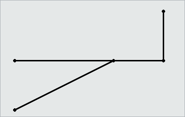
1.3 - Linestring
One or more connected lines, identified by pairs of consecutive points.
One or more connected lines, identified by pairs of consecutive points. A linestring has dimension 1. The boundary of a linestring is a multipoint object containing its start and end points.
The following are examples of linestrings:
Examples
The following example uses the GEOMETRY type to create a table, use copy to load a linestring to the table, and then queries the table to view the linestring:
=> CREATE TABLE linestring_geom (gid int, geom GEOMETRY(1000));
CREATE TABLE
=> COPY linestring_geom(gid, gx filler LONG VARCHAR, geom AS ST_GeomFromText(gx)) FROM stdin delimiter '|';
Enter data to be copied followed by a newline.
End with a backslash and a period on a line by itself.
>>1|LINESTRING(0 0, 1 1, 2 2, 3 4, 2 4, 1 5)
>>\.
=> SELECT gid, ST_AsText(geom) FROM linestring_geom;
 gid |                 ST_AsText
-----+-------------------------------------------
   1 | LINESTRING (0 0, 1 1, 2 2, 3 4, 2 4, 1 5)
(1 row)
The following example uses the GEOGRAPHY type to create a table, use copy to load a linestring to the table, and then queries the table to view the linestring:
=> CREATE TABLE linestring_geog (gid int, geog GEOGRAPHY(1000));
CREATE TABLE
=> COPY linestring_geog(gid, gx filler LONG VARCHAR, geog AS ST_GeographyFromText(gx)) FROM stdin delimiter '|';
Enter data to be copied followed by a newline.
End with a backslash and a period on a line by itself.
>>1|LINESTRING(42.1 71, 41.4 70, 41.3 72.9, 42.99 71.46, 44.47 73.21)
>>\.
=> SELECT gid, ST_AsText(geog) FROM linestring_geog;
 gid |                             ST_AsText
-----+--------------------------------------------------------------------
   1 | LINESTRING (42.1 71, 41.4 70, 41.3 72.9, 42.99 71.46, 44.47 73.21)
(1 row)
1.4 - Multilinestring
A collection of zero or more linestrings.
A collection of zero or more linestrings. A multilinestring has no dimension. The boundary of a multilinestring is a multipoint object containing the start and end points of all the linestrings.
The following are examples of multilinestrings:
Examples
The following example uses the GEOMETRY type to create a table, use copy to load a multilinestring to the table, and then queries the table to view the multilinestring:
=> CREATE TABLE multilinestring_geom (gid int, geom GEOMETRY(1000));
CREATE TABLE
=> COPY multilinestring_geom(gid, gx filler LONG VARCHAR, geom AS ST_GeomFromText(gx)) FROM stdin delimiter '|';
Enter data to be copied followed by a newline.
End with a backslash and a period on a line by itself.
>>1|MULTILINESTRING((1 5, 2 4, 5 3, 6 6),(3 5, 3 7))
>>\.
=> SELECT gid, ST_AsText(geom) FROM multilinestring_geom;
 gid |                     ST_AsText
-----+----------------------------------------------------
   1 | MULTILINESTRING ((1 5, 2 4, 5 3, 6 6), (3 5, 3 7))
(1 row)
The following example uses the GEOGRAPHY type to create a table, use copy to load a multilinestring to the table, and then queries the table to view the multilinestring:
=> CREATE TABLE multilinestring_geog (gid int, geog GEOGRAPHY(1000));
CREATE TABLE
=> COPY multilinestring_geog(gid, gx filler LONG VARCHAR, geog AS ST_GeographyFromText(gx)) FROM stdin delimiter '|';
Enter data to be copied followed by a newline.
End with a backslash and a period on a line by itself.
>>1|MULTILINESTRING((42.1 71, 41.4 70, 41.3 72.9), (42.99 71.46, 44.47 73.21))
>>\.
=> SELECT gid, ST_AsText(geog) FROM multilinestring_geog;
 gid |                                  ST_AsText
-----+----------------------------------------------------------------------------
   1 | MULTILINESTRING((42.1 71, 41.4 70, 41.3 72.9), (42.99 71.46, 44.47 73.21))
(1 row)
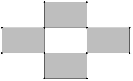
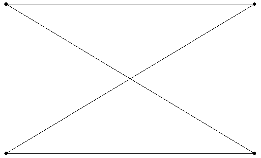
1.5 - Polygon
An object identified by a set of closed linestrings.
An object identified by a set of closed linestrings. A polygon can have one or more holes, as defined by interior boundaries, but all points must be connected. Two examples of polygons are:
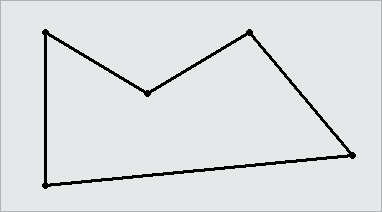
Inclusive and exclusive polygons
Polygons that include their points in clockwise order include all space inside the perimeter of the polygon and exclude all space outside that perimeter. Polygons that include their points in counterclockwise order exclude all space inside the perimeter and include all space outside that perimeter.
Examples
The following example uses the GEOMETRY type to create a table, use copy to load a polygon into the table, and then queries the table to view the polygon:
=> CREATE TABLE polygon_geom (gid int, geom GEOMETRY(1000));
CREATE TABLE
=> COPY polygon_geom(gid, gx filler LONG VARCHAR, geom AS ST_GeomFromText(gx)) FROM stdin delimiter '|';
Enter data to be copied followed by a newline.
End with a backslash and a period on a line by itself.
>>1|POLYGON(( 2 6, 2 9, 6 9, 7 7, 4 6, 2 6))
>>\.
=> SELECT gid, ST_AsText(geom) FROM polygon_geom;
 gid |                 ST_AsText
-----+------------------------------------------
   1 | POLYGON((2 6, 2 9, 6 9, 7 7, 4 6, 2 6))
(1 row)
The following example uses the GEOGRAPHY type to create a table, use copy to load a polygon into the table, and then queries the table to view the polygon:
=> CREATE TABLE polygon_geog (gid int, geog GEOGRAPHY(1000));
CREATE TABLE
=> COPY polygon_geog(gid, gx filler LONG VARCHAR, geog AS ST_GeographyFromText(gx)) FROM stdin delimiter '|';
Enter data to be copied followed by a newline.
End with a backslash and a period on a line by itself.
>>1|POLYGON((42.1 71, 41.4 70, 41.3 72.9, 44.47 73.21, 42.99 71.46, 42.1 71))
>>\.
=> SELECT gid, ST_AsText(geog) FROM polygon_geog;
 gid |                                ST_AsText
-----+---------------------------------------------------------------------------
   1 | POLYGON((42.1 71, 41.4 70, 41.3 72.9, 44.47 73.21, 42.99 71.46, 42.1 71))
(1 row)
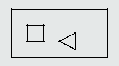
1.6 - Multipolygon
A collection of zero or more polygons that do not overlap.
A collection of zero or more polygons that do not overlap.
Examples
The following example uses the GEOMETRY type to create a table, use copy to load a multipolygon into the table, and then queries the table to view the polygon:
=> CREATE TABLE multipolygon_geom (gid int, geom GEOMETRY(1000));
CREATE TABLE
=> COPY multipolygon_geom(gid, gx filler LONG VARCHAR, geom AS ST_GeomFromText(gx)) FROM stdin delimiter '|';
Enter data to be copied followed by a newline.
End with a backslash and a period on a line by itself.
>>9|MULTIPOLYGON(((2 6, 2 9, 6 9, 7 7, 4 6, 2 6)),((0 0, 0 5, 1 0, 0 0)),((0 2, 2 5, 4 5, 0 2)))
>>\.
=> SELECT gid, ST_AsText(geom) FROM polygon_geom;
 gid |                                           ST_AsText
-----+----------------------------------------------------------------------------------------------
   9 | MULTIPOLYGON(((2 6, 2 9, 6 9, 7 7, 4 6, 2 6)),((0 0, 0 5, 1 0, 0 0)),((0 2, 2 5, 4 5, 0 2)))
(1 row)
The following example uses the GEOGRAPHY type to create a table, use copy to load a multipolygon into the table, and then queries the table to view the polygon:
=> CREATE TABLE multipolygon_geog (gid int, geog GEOGRAPHY(1000));
CREATE TABLE
=> COPY polygon_geog(gid, gx filler LONG VARCHAR, geog AS ST_GeographyFromText(gx)) FROM stdin delimiter '|';
Enter data to be copied followed by a newline.
End with a backslash and a period on a line by itself.
>>1|POLYGON((42.1 71, 41.4 70, 41.3 72.9, 44.47 73.21, 42.99 71.46, 42.1 71))
>>\.
=> SELECT gid, ST_AsText(geog) FROM polygon_geog;
 gid |                                ST_AsText
-----+---------------------------------------------------------------------------
   1 | POLYGON(((42.1 71, 41.4 70, 41.3 72.9, 42.1 71)),((44.47 73.21, 42.99 71.46, 42.1 71, 44.47 73.21)))
(1 row)
2 - Spatial object representations
The OGC defines two ways to represent spatial objects:.
The OGC defines two ways to represent spatial objects:
2.1 - Well-known text (WKT)
Well-Known Text (WKT) is an ASCII representation of a spatial object.
Well-Known Text (WKT) is an ASCII representation of a spatial object.
WKTs are not case sensitive; Vertica recognizes any combination of lowercase and uppercase letters.
Some examples of valid WKTs are:
| WKT Example | Description |
|---|---|
| POINT(1 2) | The point (1,2) |
| MULTIPOINT(0 0,1 1) | A set made up of the points (0,0) and (1,1) |
| LINESTRING(1.5 2.45,3.21 4) | The line from the point (1.5,2.45) to the point (3.21,4) |
| MULTILINESTRING((0 0,–1 –2,–3 –4),(2 3,3 4,6 7)) | Two linestrings, one that passes through (0,0), (–1,–2), and (–3,–4), and one that passes through (2,3), (3,4), and (6,7). |
| POLYGON((1 2,1 4,3 4,3 2,1 2)) | The rectangle whose four corners are indicated by (1,2), (1,4), (3,4), and (3,2). A polygon must be closed, so the first and last points in the WKT must match. |
| POLYGON((0.5 0.5,5 0,5 5,0 5,0.5 0.5), (1.5 1,4 3,4 1,1.5 1)) | A polygon (0.5 0.5,5 0,5 5,0 5,0.5 0.5) with a hole in it (1.5 1,4 3,4 1,1.5 1). |
| MULTIPOLYGON(((0 1,3 0,4 3,0 4,0 1)), ((3 4,6 3,5 5,3 4)), ((0 0,–1 –2,–3 –2,–2 –1,0 0))) | A set of three polygons |
| GEOMETRYCOLLECTION(POINT(5 8), LINESTRING(–1 3,1 4)) | A set containing the point (5,8) and the line from (–1,3) to (1,4) |
|
POINT EMPTY MULTIPOINT EMPTY LINESTRING EMPTY MULTILINESTRING EMPTY MULTILINESTRING(EMPTY) POLYGON EMPTY POLYGON(EMPTY) MULTIPOLYGON EMPTY MULTIPOLYGON(EMPTY) |
Empty spatial objects; empty objects have no points. |
Invalid WKTs are:
-
POINT(1 NAN), POINT(1 INF)—Coordinates must be numbers.
-
POLYGON((1 2, 1 4, 3 4, 3 2))—A polygon must be closed.
-
POLYGON((1 4, 2 4))—A linestring is not a valid polygon.
2.2 - Well-known binary (WKB)
Well-Known Binary (WKB) is a binary representation of a spatial object.
Well-Known Binary (WKB) is a binary representation of a spatial object. This format is primarily used to port spatial data between applications.
3 - Spatial definitions
The OGC defines properties that describe.
The OGC defines properties that describe
-
Characteristics of spatial objects
-
Spatial relationships that can exist among objects
Vertica provides functions that test for and analyze the following properties and relationships.
3.1 - Boundary
The set of points that define the limit of a spatial object:.
The set of points that define the limit of a spatial object:
-
Points, multipoints, and geometrycollections do not have boundaries.
-
The boundary of a linestring is a multipoint object. This object contains its start and end points.
-
The boundary of a multilinestring is a multipoint object. This object contains the start and end points of all the linestrings that make up the multilinestring.
-
The boundary of a polygon is a linestring that begins and ends at the same point. If the polygon has one or more holes, the boundary is a multilinestring that contains the boundaries of the exterior polygon and any interior polygons.
-
The boundary of a multipolygon is a multilinestring that contains the boundaries of all the polygons that make up the multipolygon.
3.2 - Buffer
The set of all points that are within or equal to a specified distance from the boundary of a spatial object.
The set of all points that are within or equal to a specified distance from the boundary of a spatial object. The distance can be positive or negative.
Positive buffer:
Negative buffer:
3.3 - Contains
One spatial object contains another spatial object if its interior includes all points of the other object.
One spatial object contains another spatial object if its interior includes all points of the other object. If an object such as a point or linestring only exists along a polygon's boundary, the polygon does not contain it. If a point is on a linestring, the linestring contains it; the interior of a linestring is all the points on the linestring except the start and end points.
Contains(a, b) is spatially equivalent to within(b, a).
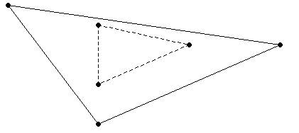
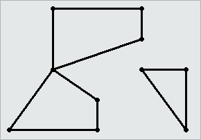
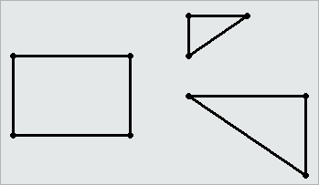
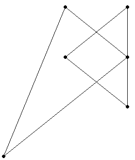
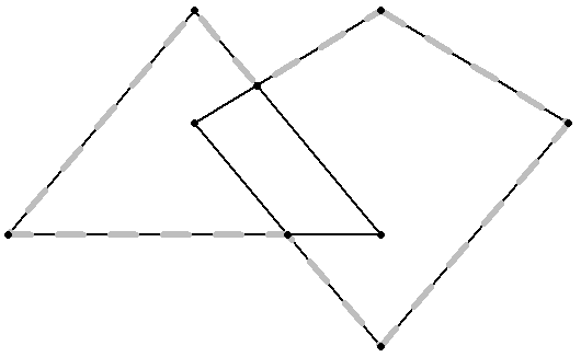
3.4 - Convex hull
The smallest convex polygon that contains one or more spatial objects.
The smallest convex polygon that contains one or more spatial objects.
In the following figure, the dotted lines represent the convex hull for a linestring and a triangle.
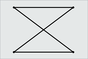
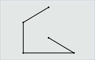
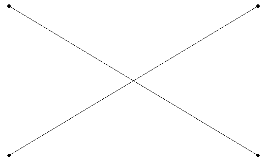
3.5 - Crosses
Two spatial objects cross if both of the following are true:.
Two spatial objects cross if both of the following are true:
-
The two objects have some but not all interior points in common.
-
The dimension of the result of their intersection is less than the maximum dimension of the two objects.
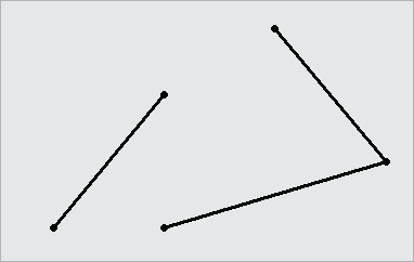
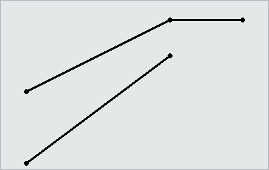
3.6 - Disjoint
Two spatial objects have no points in common; they do not intersect or touch.
Two spatial objects have no points in common; they do not intersect or touch.
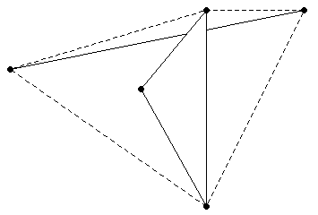
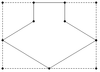
3.7 - Envelope
The minimum bounding rectangle that contains a spatial object.
The minimum bounding rectangle that contains a spatial object.
The envelope for the following polygon is represented by the dotted lines in the following figure.
3.8 - Equals
Two spatial objects are equal when their coordinates match exactly.
Two spatial objects are equal when their coordinates match exactly. Synonymous with spatially equivalent.
The order of the points do not matter in determining spatial equivalence:
-
LINESTRING(1 2, 4 3) equals LINESTRING(4 3, 1 2).
-
POLYGON ((0 0, 1 1, 1 2, 2 2, 2 1, 3 0, 1.5 –1.5, 0 0)) equals POLYGON((1 1 , 1 2, 2 2, 2 1, 3 0, 1.5 –1.5, 0 0, 1 1)).
-
MULTILINESTRING((1 2, 4 3),(0 0, –1 –4)) equals MULTILINESTRING((0 0, –1 –4),(1 2, 4 3)).
3.9 - Exterior
The set of points not contained within a spatial object nor on its boundary.
The set of points not contained within a spatial object nor on its boundary.
3.10 - GeometryCollection
A set of zero or more objects from any of the supported classes of spatial objects.
A set of zero or more objects from any of the supported classes of spatial objects.
3.11 - Interior
The set of points contained in a spatial object, excluding its boundary.
The set of points contained in a spatial object, excluding its boundary.
3.12 - Intersection
The set of points that two or more spatial objects have in common.
The set of points that two or more spatial objects have in common.
3.13 - Overlaps
If a spatial object shares space with another object, but is not contained within that object, the objects overlap.
If a spatial object shares space with another object, but is not contained within that object, the objects overlap. The objects must overlap at their interiors; if two objects touch at a single point or intersect only along a boundary, they do not overlap.
3.14 - Relates
When a spatial object is spatially related to another object as defined by a DE-9IM pattern matrix string.
When a spatial object is spatially related to another object as defined by a DE-9IM pattern matrix string.
A DE-9IM pattern matrix string identifies how two spatial objects are spatially related to each other. For more information about the DE-9IM standard, see Understanding Spatial Relations.
3.15 - Simple
For points, multipoints, linestrings, or multilinestrings, a spatial object is simple if it does not intersect itself or has no self-tangency points.
For points, multipoints, linestrings, or multilinestrings, a spatial object is simple if it does not intersect itself or has no self-tangency points.
Polygons, multipolygons, and geometrycollections are always simple.
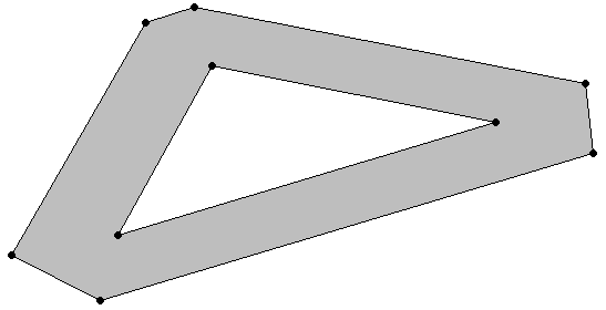
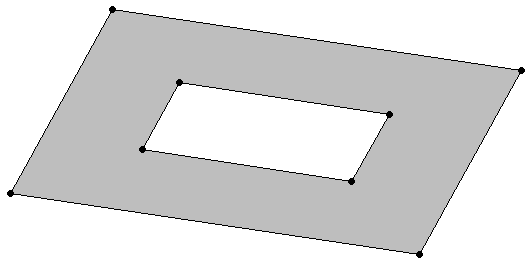
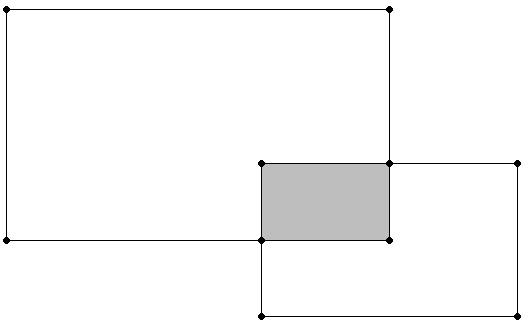
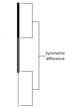
3.16 - Symmetric difference
The set of all points of a pair of spatial objects where the objects do not intersect.
The set of all points of a pair of spatial objects where the objects do not intersect. This difference is spatially equivalent to the union of the two objects less their intersection. The symmetric difference contains the boundaries of the intersections.
In the following figure, the shaded areas represent the symmetric difference of the two rectangles.
The following figure shows the symmetric difference of two overlapping linestrings.
3.17 - Union
For two or more spatial objects, the set of all points in all the objects.
For two or more spatial objects, the set of all points in all the objects.
3.18 - Validity
For a polygon or multipolygon, when all of the following are true:.
For a polygon or multipolygon, when all of the following are true:
-
It is closed; its start point is the same as its end point.
-
Its boundary is a set of linestrings.
-
No two linestrings in the boundary cross. The linestrings in the boundary may touch at a point but they cannot cross.
-
Any polygons in the interior must be completely contained; they cannot touch the boundary of the exterior polygon except at a vertex.
Valid polygons:
Invalid polygon:
3.19 - Within
A spatial object is considered within another spatial object when all its points are inside the other object's interior.
A spatial object is considered within another spatial object when all its points are inside the other object's interior. Thus, if a point or linestring only exists along a polygon's boundary, it is not considered within the polygon. The polygon boundary is not part of its interior.
If a point is on a linestring, it is considered within the linestring. The interior of a linestring is all the points along the linestring, except the start and end points.
Within(a, b) is spatially equivalent to contains(b, a).